In these pages (1-4) you can find and download various samples of Microworlds constructed with E-Slate. To use them, you have to first download and install E-Slate from the Download area. After that you may open Microworlds (.mwd files) from within E-Slate. Alternativelly, you can double-click on these files to launch E-Slate. Note that in some cases Microworlds are accompanied by various multimedia assets (packed in .zip files) which should always be kept at the relative file locations indicated by the installation file structure.
Copyright Notice and Terms of Use: The provided Microworlds and materials are distributed on an "as is" basis, for any non-commercial use. In all cases, their use should be accompanied by the "Credits" notice as it appears below.
Foreign Language Learning ("Xenios") A series of Microworlds for learning foreign languages (English, French, German) designed around the idea of traveling to the mother countries, seeing places and talking to locals.
|
|
||||||||||||||||||||||||||
|
Cartography by small children Game-like activities for small children (5-6) to experiment with space and time using portable GPS devices and tools for creating maps.
|
|
||||||||||||||||||||||||||
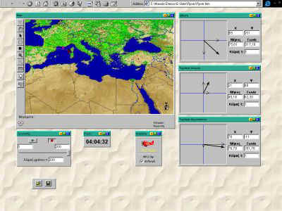
The Flying Vectors "Flyver" is about navigating around a map, particularly the scenario of a pilot of a plane affected by wind, or of a boat affected by currents and tides. Pupils are encouraged to use this microworld as they travel around Europe in pursuit of cultural, geographical and other excitements.
|
 |
||||||||||||||||||||||||||
Communicating to meet An activity designed to encourage learning through communication, involvement, exploration, experimentation, collaboration and productivity. Two or more classrooms are set the task to justify, collectively work out and produce a proposal or plan for an exchange of visits.
|
|
||||||||||||||||||||||||||
Treasure hunt in Attica In the search of a hidden treasure, pupils are wandering around Attica and the city of Athens, based on vague descriptions on where the treasure is hidden. They engage themselves in geographical thinking and interpetation of landmarks, map symbols and spatial directions.
|
|
||||||||||||||||||||||||||